
4 Trails as Land Use and Public Access Tools in Michigan
“The planning phase is one of the most critical steps in creating a quality linked trail network. It is essential to gather pertinent information, identify challenges and opportunities, conduct meaningful public engagement, and collaborate with all stakeholders. Carrying out a detailed planning process early on in a project will also help to identify potential funding sources and lay the groundwork for future design, construction, programming, and maintenance activities.”
—Kristen Wiltfang, Oakland County Department of Economic Development, Administrator—Trails, Transportation, and Environment
Chapter Objectives and Goals
This chapter will discuss the significant role played by trails in providing the public with sustainable access to natural resources to serve public interest. Trails provide more than recreation and transportation corridors as they are valuable land use tools used at federal, state, and local levels to conserve natural resources and provide numerous other benefits. As communities plan for their future land uses, trails are an important land use tool to link communities, provide buffers from development, protect natural resources, and increase property values. This chapter also highlights the role of public engagement in trail planning. It is important for readers to appreciate the significant role that trails can play in land use planning, business attraction and retention, and helping to provide a higher quality of life for residents within and in proximity to trail-based communities.
Key Questions to Consider as You Read this Chapter:
- What is an essential goal of any land use planning effort?
- Explain the connection between federal, state, and local land use planning.
- How do trails help preserve open space and protect sensitive areas?
- In what ways do trails provide social benefits for a community and its residents?
- What is the most important early component in any land use plan?
- How can trails help create a stronger sense of community?
- How can trails protect natural resources, while still providing access?
- Why is it so important to have one or two key individuals acting to lead a vision for local trails?
- What are some of the benefits of a multi-jurisdictional trail?
- Why are trails politically popular?
Introduction
Trails are a valuable land use tool that provide many benefits, including, but not limited to:
- Creating conservation corridors to protect wildlife habitat and natural resources
- Enhancing local recreation plans and community master plans
- Promoting local history and culture
- Connecting people and communities
- Supporting of local and regional economies
- Increasing local and regional transportation routes
For these reasons, land use planning in any community is enhanced when trails are included as part of the planning process.
What is Land Use Planning?
Land use planning is an orderly, systematic approach to managing the built infrastructure, land, natural features, and water resources within a community to preserve the essential, desired characteristics of a community. It is a dynamic and ongoing process that is fed by citizen engagement and guided by planning professionals with the ultimate goal of effectively meeting the needs of today and conserving resources for many generations to come.
Planning can be carried out at a variety of governmental levels. For example, land use planning at the federal level can be seen through the national park and forest systems, highway systems, coastal zone management areas, and many other national programs. There are also significant state-based land use programs that can interact with local planning efforts. For example, state conservation programs that provide protection for natural areas like wetlands, sand dunes, and natural rivers can help provide conservation buffers and complementary benefits to local planning programs. Planning becomes more focused and relevant to local residents as it progresses down through the layers of government. As compared to other governmental levels, land use planning at the local level (i.e., city, county, township, or village) can be more precise and therefore more capable of reflecting the will of members of the local community.
Home Rule in Michigan
Michigan is a “home rule” state, meaning that local governments are granted general powers of self-governance related to matters of local concern, with some limitations around fiscal authority (LSSC 2019). The Michigan Planning Enabling Act (Public Act 33 of 2008, as amended) and the Michigan Zoning Enabling Act (Public Act 110 of 2006, as amended) grant local governments the authority to develop and enforce local zoning ordinances. It is important to note that a land use plan is a guide, while a zoning ordinance is the enforceable law.
Outcomes of Effective Land Use Planning
Because citizen engagement in the planning process is critical, most observers agree that comprehensive land use planning is often most effective at the local level. There are several important outcomes associated with effective land use planning, such as:
- Allows residents to feel empowered to express their needs in the community
- Promotes inclusive, diverse, and connected communities
- Considers a mix of transportation infrastructure for walking, micromobility/biking, people with disabilities, transit, freight, and motor vehicles
- Emphasizes the importance of quality of place
- Encourages more efficient and effective governments
- Recommends the review and update of policies and zoning ordinances
- Analyzes a variety of data such as demographics, land cover, existing land uses, spending habits, housing stock, public health, economic, and workforce characteristics
- Creates and supports more sustainable futures for the community and regions of the state
- Supports business attraction and retention which can be a draw for well qualified workers
-

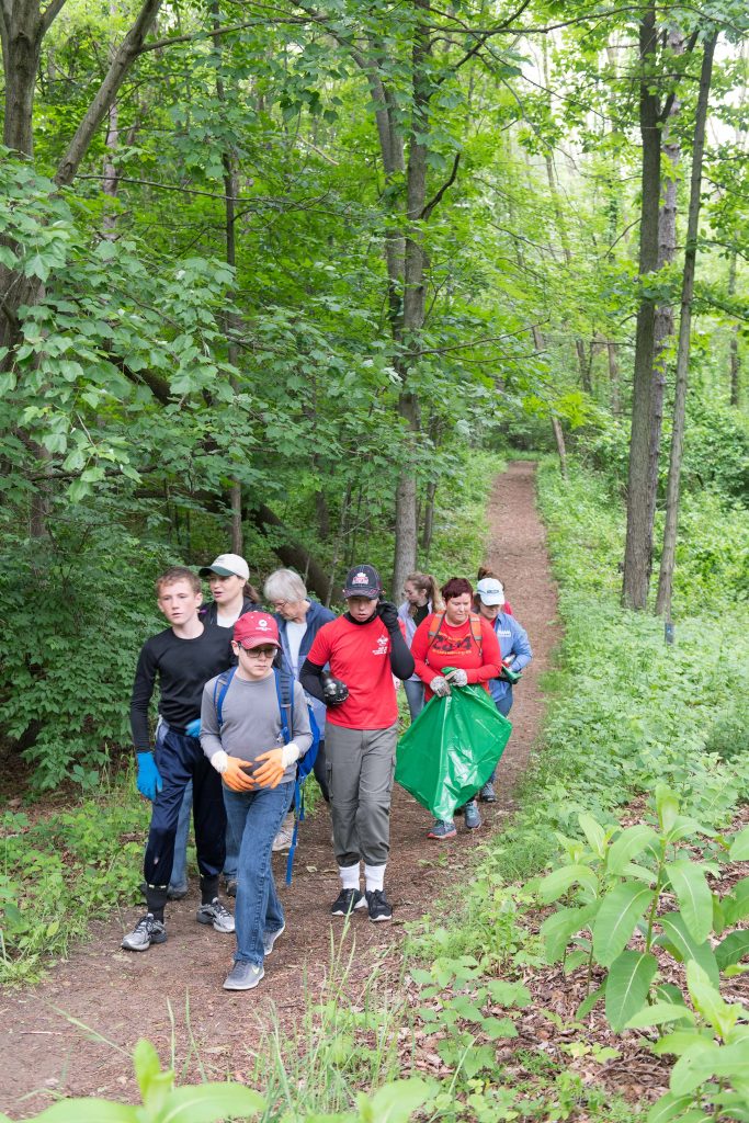
Trails provide valuable public access to outdoor recreation for families. © Michigan Department of Natural Resources. All rights reserved. Used with permission.
Components of Land Use Plans
There are essential components that should be found in any effective land use plan such as regular public input and coordination with multiple levels of government, key stakeholders, and adjacent communities. Land use plans also need to be adaptable, flexible, and responsive to changes in conditions. As such, land use planning requires regular revisions, typically every five years, and monitoring by both local planning officials and residents so that as conditions and needs within a community change, land use plans can change accordingly.
Once a plan is developed, enforceable land use mechanisms such as zoning ordinances, conservation easements, site plan reviews, and property acquisitions (e.g., purchases of land by a local unit of government or partnering land conservancy) are important tools to implement the recommendations of the planners. For most communities, zoning compliance is the most frequently used tool and provides for both specific and general categories of land use within a community.
Land Use Planning and Trails
Land use plans typically include guidelines and goals for the conservation of both natural and man-made features. Because of the opportunities that trails can provide to advance those conservation efforts and other related benefits, many communities include trails and trail development in their land use plans. Communities such as Traverse City, Detroit, Oakland Township, Meridian Township, Marquette, Grand Rapids, Pinckney, Charlevoix, East Tawas, Ann Arbor, South Haven, and Kalamazoo are examples of trail-rich communities that have made a concerted effort to include trails as essential infrastructure incorporated into their plans. The following sections outline the main benefits of including trails in land use plans.
Trails Protect and Provide Access to Natural Resources
Trails serving as conservation corridors can help preserve open space and protect sensitive environmental areas such as wetlands, woodlands, steep slopes, and wildlife habitat. They can also help maintain naturally functioning ecosystems. Trail systems can help establish a network of natural landscape corridors that provide buffers from built infrastructure (e.g., roads, buildings, parking lots, and utilities), help manage stormwater runoff, and reduce impacts of development on the natural environment.
Trails Support Local Recreational Needs
Trails also help support local recreational needs by providing a wide variety of opportunities such as hiking, bicycling, canoeing, kayaking, motorized recreational vehicle use, equestrian use (e.g., horseback riding and driving), and seasonal opportunities like cross-country skiing and snowmobiling. Supporting these recreation activities also helps promote healthy active lifestyles. Trail use has been linked to improvements in a community’s collective physical and mental health (American Trails Staff n.d.).
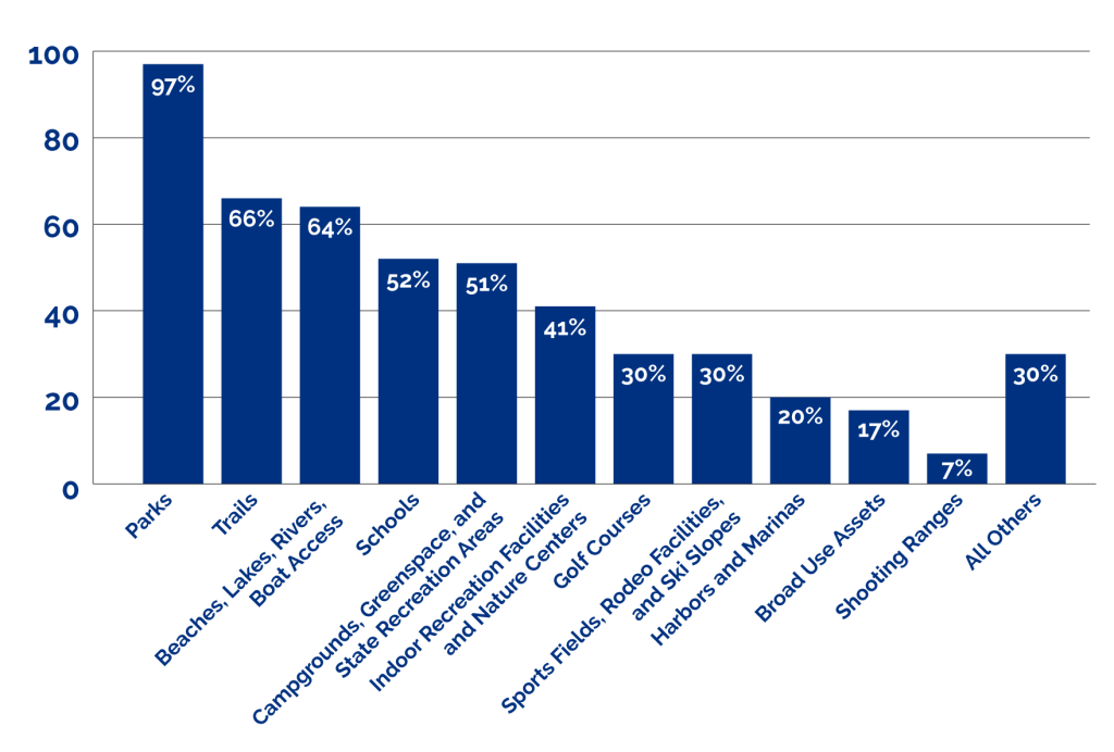
Local recreation and planning officials strive to develop appropriate recreational facilities that reflect the needs of residents. Recent Michigan Department of Natural Resources (DNR) studies indicate that trails have been and continue to remain among the most popular recreational amenities included in local five-year recreation master plans. For example, in a survey conducted during the development of the 2018-2022 Michigan Statewide Comprehensive Outdoor Recreation Plan (SCORP), the DNR found that 66 percent of all local five-year recreation master plans list trails as an outdoor recreation asset (Exhibit 1).
Exhibit 1. Percentage of Five-Year Master Plans that Include Lists of Outdoor Recreation Assets
Many local recreation plans utilize trails to connect existing parks and facilitate event planning for a variety of recreational activities (e.g., running, biking, kayaking, etc.). The Little Traverse Bay Marathon is an excellent example of an event that utilizes a trail corridor to support a safe and exciting running event along the Lake Michigan shoreline.
Trails Promote Local History and Cultural Assets
Many land use planners incorporate historical and cultural features into the planning of a community. Preserving historical sites provides an opportunity for people to understand the heritage of an area. Trails are an excellent method of promoting local history and culturally significant destinations. There are many trails in Michigan that utilize interpretive elements to convey the historical and/or cultural context of the area. These interpretive efforts can range from physical signs to technology that utilizes mobile applications, to physical pieces of art and artifacts, and even guided tours along the trail.
Trails Connect Communities

Trails can also facilitate social connections for members within a community and neighboring communities by helping to build new and existing relationships between the community and public and private groups. Because the development and management of a trail often requires cooperation and coordination, private landowners, land conservancies, developers, recreation and environmental groups, and public agencies all need to work together. This cooperation can help develop a sense of collective pride and investment in trails, which can also lead to other benefits for the community. Trails can also link neighborhoods with parks, recreation areas, schools, business, natural features, downtowns, and cultural points of interest. In this way, trails clearly connect people and build stronger communities.
Trails Benefit Local Economies
There are many well-demonstrated positive economic effects of trail development to a community. Studies have shown that properties near trails typically increase in value and that the presence of trails increases local tourism and related business and industry expenditures (Webel 2018). Trails also help attract and support new business opportunities and job creation. A 2011 study found that pedestrian and bicycle infrastructure projects create between eight to twelve jobs per $1 million in investment and create opportunities for adjacent and nearby developments, both residential and commercial (Garrett-Peltier 2011).
Trails Serve as Transportation Routes
Trails can serve as local, sustainable, “alternative” transportation routes. Initiatives such as the Safe Routes to School, Safe Routes to Parks, and Complete Streets programs provide funding and support for such routes. These alternative methods of transportation help reduce a community’s carbon footprint and promote a healthy lifestyle for everyday travel trips, commuting, and other transportation needs. In addition, since every transit trip starts with walking or rolling, trails can offer transit users safe, welcoming connections to and from bus routes.
Trails and Greenway Planning
A trail plan (also sometimes referred to as a “greenway” plan) is a document that outlines goals and objectives for the development and maintenance of a trail system. A trail plan can stand alone, or it can be part of a comprehensive master plan for a community. If the trail plan is a standalone document at some point it should be effectively coordinated with the community’s larger land use plan. As illustrated in Exhibit 2, there are several stages in the development of a trail plan that mirror the land use planning process.
Exhibit 2. Stages in the Trail Planning Process

The early planning process is the most important step in developing a trail plan. During this stage of the process, planners discuss concepts and engage with the public and key stakeholders, on the following topics including (but not limited to), route alternatives, legislation and policy considerations, accessibility, potential barriers or challenges, signage, maintenance, cost estimates, and funding sources. Any trail concept must be grounded in the principles of sustainability so that what is built can be effectively maintained in the future given available resources. Next, planners establish goals and objectives and identify specific action items which will help guide the implementation of the plan. The planning process culminates in a written plan that outlines all relevant material and includes maps of existing and proposed trails and major destinations. Trail plans often require approval from local public officials.
Trail planning often starts with one or two individuals or an organization that has a vision for a trail in the community. It is important to identify a local champion who is willing to spearhead the project and invest time in becoming a trail leader or trail stewardship coordinator. There are many instances where a trail has been successfully started when one person steps up to lead the initiative and works to build community support from the outset. That person is generally both passionate and persuasive and helps “prime the pump” in getting early local endorsements and obtaining early sources of funding.
Public participation is a critical element of any successful trail plan. It is important to develop and foster stakeholder relationships and seek public input early in the process. Through regular meetings and using a variety of outreach methods, the trail planning process can gain meaningful input, identify potential concerns, evolve the project, and keep people informed. It is essential to develop effective communications with the area residents, business owners, elected officials, utility companies, and other key stakeholders. Finding ways to generate excitement for the plan and keeping momentum going forward is also critical.
How to Design a Connected Trail Network
- Develop a base map with pertinent information like parks, existing trails, natural features, road network, historic sites, schools, scenic vistas, town centers, and commercial corridors.
- Identify existing and future population densities. Make sure trails are in close proximity to the densely populated areas.
- Identify the user types permitted to use the trail like pedestrians, cyclists, and/or equestrians.
- Identify important destinations and community features to be linked by the trail network such as town centers, parks, natural areas, libraries, historic sites, job centers, and schools.
- Consider the different corridor options for a trail such as a utility corridor, park, former railroad corridor, along parcel boundaries, road rights-of-way or riparian corridors.
- Identify potential conflicts or barriers that may include sensitive natural areas, steep slopes, road or driveway crossings, or unsupportive adjacent property owners.
- Look beyond the local municipal boundaries and work with adjacent communities to make connections.
- Identify potential trailheads, access points, and locations for amenities like restrooms, drinking fountains, or bike repair stations.
- Develop a method to measure and track success and implementation of the plan.
Regionalization of Trails
Michigan is fortunate to have statutory law that encourages the development of multi-jurisdictional interconnected trail systems. The statutory authorization and legislative intent found in the Michigan Trailways Act (MTA) has helped fuel the development of many such interconnected trail networks around the state. The Great Lake-to-Lake Trail, Route 1 that stretches from South Haven and Port Huron is an example of an interconnected network that allows for a trail user to move from Lake Michigan to Lake Huron.
Multi-jurisdictional Trail Planning Councils
The MTA specifically allows for the creation of multi-jurisdictional trail planning councils that help coordinate with communities within a region in their efforts to build and manage trails. Each local unit of government that exists within a trail corridor can be represented on such a trail-governing council, effectively managing a trail that has multiple benefits for the region.
“Trailshed” Management
Watershed management is a regional planning concept that coordinates the conservation and management of water resources within a region. Trail managers around the state are beginning to apply a similar regional approach in managing trails. This concept of “trailshed” management can help drive a trail plan that coordinates local resources and needs with regional, state, and federal resources and needs.
Conclusion
Land use planning can sometimes be a controversial issue in Michigan, due to a variety of policy and political issues. Incorporating trail planning into broader land use plans can provide opportunities for more successful and effective land use planning for a number of reasons:
- Trails are often a non-threatening land use tool that can protect property rights and accommodate and promote business and consumer use while simultaneously protecting natural resources.
- Trails are often politically popular, and generally not controversial as long as the vision is communicated early and often.
- Trails promote diverse access and sustainable uses of a community’s natural resource base.
- Trails provide an opportunity to connect people and their communities, both literally and figuratively.
All governments owe a responsibility to the people to serve the public interest and promote the public good. Trails provide a unique solution to that challenge so long as they are built to provide access and sustain natural resources. An effective land use planning and implementation process at the local level can help government meet that doctrinal charge. In times of shifting social circumstances where there is a real need for people to connect with one another and the natural resources that grace their communities, having a vibrant and sustainable trail system is a critical component for making communities stronger and healthier.
Group Discussion Topics
The Public Trust Doctrine (PTD) is rooted in early English and Roman law. Since then, it has evolved through time to address added development pressures in order to continue to provide public access. Please describe the key differences and similarities between the early foundations of PTD and PTD as we know it today in the United States.
Trails are declared “a public purpose” in the Michigan Trailways Act. In terms of guiding future legislative decisions, why is this significant? What proposal would you make to help increase accessibility of the public in Michigan to our trails? Where do we need to improve accessibility and long-term availability of our trails?
References
American Trails Staff. n.d. “Health Benefits of Trails.” American Trails. Accessed April 16, 2024. https://www.americantrails.org/resources/health-benefits-of-trails
Garrett-Peltier, Heidi. June 2011. Pedestrian and Bicycle Infrastructure: A National Study of Employment Impacts. Amherst: University of Massachusetts Amherst. Accessed April 17, 2024. https://backend.orlis.difu.de/server/api/core/bitstreams/e60ae99d-e7d1-4521-838f-9bbb6c53a6b9/content
Local Solutions Support Center (LSSC). December 2019. “Home Rule in Michigan.” LSSC. Accessed May 22, 2024. https://static1.squarespace.com/static/5ce4377caeb1ce00013a02fd/t/5eb3444d507a0176a3df1d10/1588806734912/50+States+–+MI+Home+Rule+%282020+updates%29+%28final%29.pdf
Michigan Department of Natural Resources (DNR). 2018. Michigan Comprehensive Statewide Outdoor Recreation Plan: 2018-2022. Lansing: DNR. Accessed April 16, 2024. https://www.michigan.gov/-/media/Project/Websites/dnr/Documents/PRD/Mgt/SCORP2018-2022_Final2.pdf?rev=84364b127fdb4c01af133703077176ef#:~:text=The%20overarching%20goal%20for%20the,visitors%20and%20support%20economic%20prosperity
Webel, Suzanne. April 3, 2018. “Trail Effects on Neighborhoods: Home Value, Safety, Quality of Life.” American Trails. Accessed April 17, 2024. https://www.americantrails.org/resources/trail-effects-on-neighborhoods-home-value-safety-quality-of-life
